
|
|
|
|
Introduction
Find the Current Version
Quick Reference
UTM Zones
Online Map Sites
Points of Interest
Cool things to do with your GPS
Related Web Information
GPS Devices
Navigation Bar
Back to GPS in this window, you are lost?(All of the links that follow open in new browser windows.)
I just happened upon this great piece of software one day. It looks like it has been updated every few days, so check the site often for the most current version. I have tried several on-going versions; it seemed to work as described. It does seem to hang at times when downloading data, but the concept by far out-weighs this minor technical problem. Making the elevation contours work is a bit tricky, so carefully follow the directions in the latest ''Converts SDTS Data.txt'' file. The good news is that the elevation files are free if you download them at 56K, look over the download buttons carefully! I rate this software at 4 1/2 of 5 stars, despite the fact that the aerial photos are five to ten years old, that is not Doug's fault.
The software is stand alone within Windows. Just unzip all the files into a folder and click ''USAPhotoMaps.exe'' to begin, or make a shortcut to your desktop for easier access. When you run it you will first see a grid, fill up the grid with photos by choosing ''File | Download Map Data | Fill Screen'' then move to another spot with the arrow keys and fill it up again. It's that simple. Start a ''New Map Area'' if you are changing UTM zones, and be sure and read all of the HELP files for further details using UTM Zones if you are not familiar with them. The software includes all necessary .dll files and does not change your registry unless you select a Comm Port in GPS -Comm Port on the Title bar.
Feel free to save a copy of Kim's Notes for USAPhotoMaps ''index.html'' file in your USAPhotoMaps Folder for your own use. In fact some of the links below will not work unless you do. If you are stuck in a buttonless frame on my site, simply right click your mouse and ''Open Frame in New Window'' or ''click here'' to display it in a regular browser window, then save the file as you usually would. Also save any images that are on this page in the same folder such as the US UTM Zones Image - (us-utm-270x230.gif) and the wallpaper (map-wp.gif) by right clicking on them and ''Save Picture as..." into the same folder. If your browser has site archiving turned on and that method does not work, then another alternative way of doing this is to ''View - Source'' and save the file as ''index.html'' in the USAPhotoMaps folder. Then in Windows Explorer make a shortcut for the ''index.html'' and put it with your other USAPhotoMaps shortcuts, rename the shortcut to something like ''Kim's Notes for USAPhotoMaps'' if that is how you are used to doing things.
-Kim
Find the Most Current Version(s):
The current version components are:
USAPhotoMaps
ConvertSDTSData
BigJpeg
Web site (for updates of USAPhotoMaps and other useful programs) is: JDMCox Software,
Primary URL: http://jdmcox.com/ Alternate URL: http://dcox116.home.attbi.com/
USAPhotoMaps downloads U.S.Geological Survey aerial photos from http://terraserver.homeadvisor.msn.com/ and creates a contiguous scrollable, zoomable, GPS-enabled map from them.ConvertSDTSData is an auxiliary program that allows USAPhotoMaps to show elevations and contour lines.
BigJpeg makes a 'BIG' JPEG (.jpg) file from your USAPhotoMaps data.
You can see the date of any group of photos by going to TerraServer Homepage, and entering in the Advanced Find box the city in or near that group of photos. The date will be on the following screen.
The conversion routines between UTM and Lat/Lon can be found at: Latitude/Longitude to UTM Conversions. def: UTM - Universal Transverse Mercator
Download your free USGS elevation data file(s) from STDT_DL_b (ref. ATDI - Radio Network Planning Solutions)
Follow Doug's directions in the ''Convert SDTS Data.txt'' very carefully!Included Documentation: ( * - The text links will not open on this webpage unless you had saved and open this index.html file in your USAPhotoMaps folder. Just use [Help | About] and [GPS | Help] in the program.)
USAPhotoMaps:
USAPhotoMaps.txt* - Overview and Contact Information.GPSHelp.txt* - Advanced User and GPS Information.
WhatsNew.txt - Version History. http://www.jdmcox.com/WhatsNew.txt
Convert SDTS Data:
Convert SDTS Data.txt* - Directions for downloading and converting elevation and contour data.BigJpeg:
BigJpeg.txt* - Directions for making 'BIG JPEG' (.jpg) files from USAPhotoMaps data.Screen JPEG:
View the Screen JPEG* in a browser window. (Mine if this ''index.html'' is on my server, or yours if this ''index.html'' is in your USAPhotoMaps folder.)Dowloading Errors:
The Downloading Errors can be read from DownloadError.htm* in the USAPhotoMaps folder if they have occurred.Extra Files for Advanced GPS Users: from jdmcox.com's website. (ref. GPSHelp.txt)
ReadGarmin.exe - Translates the file 'GPS.dta' to 'GarminGPS.txt'.NetStumbler2USA.exe - Translates the NetStumbler Summary Export File to an XML Waypoint File.
Applications on the web that supports either *.LOC, *.GPX, or both file formats: I highly recommend downloading EasyGPS.
EasyGPS - [FREE] Waypoint Management Application, use with USAPhotoMaps and or your GPS etc.
GPSBabel - [FREE] Console-based application for converting LOC and GPX to various other formats.
Clayjar Watcher - [FREE] Manages your Geocaching Pocket Query GPX files.
GPX Spinner - [Shareware] Converts GPX files to iSolo and Plucker format. - geocaching
Author Contact Info:
Is on his site!
USAPhotoMaps Quick Reference:
F1 ~ Help Using (basic)
F ~ Download Aerial Photos (or Topographical Images if you are in that view).
T ~ Switch to Topographical Images.
P ~ Switch to Aerial Photo Images.
U ~ Switch to Urban Area Photo Images.
Alt + S ~ Cancel The Downloading (same as clicking on [Stop Downloading]).
ALT + V and then O ~ Turns UTM Grid ON/OFF.
C ~ Turns Contours ON/OFF, if you are in Zoom Level 1 and the elevation data has been added for the location(s).
Left Mouse Click ~ On Map, Enter a Waypoint.
Q ~ Shows the row name of the data file (picture) the mouse pointer is over, press any other key to turn off this function.
X ~ Puts the mouse pointer location (that's showing on the Title bar) in a box so you can copy it and then paste it into another application. (Also lat/lon for downloading elevation data.) Cool new feature, also generates a ''screenshot'' type URL for browser(s) etc. with 4 meter/pixel topos. Copy and Paste.
1 - (Press and Hold) Shows empty 8 meters per pixel aerial photos as grey squares in zoom levels 8 thru 64.
7 - Toggles the 7.5 minute boundery grid as used by elevation area files.
Right Mouse Click ~ On Map, Waypoint Menu.
Space Bar ~ Display your current position with a Dot if your GPS is receiving a satellite position.
Shift + (Mouse Move) ~ Draws a line on which to enter text on the map. (Works at 1 or 2 meter zoom level only, 60 character limit per entry.)
Delete Key ~ Deletes the Aerial Photo or the Topographical Image that the mouse pointer is over.
Scroll the Map:
Up Arrow ~ Scrolls NorthZooming:
Down Arrow ~ Scrolls South
Left Arrow ~ Scrolls West
Right Arrow ~ Scrolls East
Ctrl + Page Up ~ Zooms Out (location at the mouse pointer will go to roughly the center of the screen).Page Up ~ Zooms Out / Higher Altitude
8 Meters per Pixel Resolution:Page Down ~ Zooms In / Lower Altitude64 meters / pixel1 Meter per Pixel Resolution:
32 meters / pixel ~ (Topographical Images Minimum Zoom).
16 meters / pixel
8 meters / pixel4 meters / pixel ~ (Topographical Images 'Default' Maximum Zoom).
2 meters / pixel
1 meters / pixel ~ Default (Contours display only at this setting).Ctrl + Page Down ~ Zooms In (location at the mouse pointer will go to roughly the center of the screen).
Line To Distance:
From the Current Mouse Pointer Position:Alt + W and then L ~ To select from the Waypoints List.or
Alt + T and then L ~ To select from the Text Entries List.
(All distances are in miles.)
Routes:
Alt + R then C ~ Selects ''Create | Routes'' from the menu bar.Left Mouse Click ~ Makes a point, move mouse and Left Mouse Click to continue making points.Ctrl + Z ~ Deletes the last point.
Double Left Mouse Click ~ Finishes the route, and opens the ''Save Route Window''.
(Route cumulative distance is shown is in feet if it is less than 1,000 feet, or decimal miles if over.)
Some Basic Guides and Maps for UTM Zones:
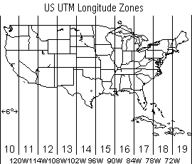
| Longitude(s): | UTM Zone: |
World Maps: - which show you the United States!
UTM Zones of the World - ref. dmap.co.uk - (Best Map!)
UTM Zones - ref. jpl.nasa.gov
State Maps:
UTM Zones of Kansas - ref. ukans.edu
UTM Zones of North Carolina - ref. state.nc.us
UTM Zones of Texas - ref. state.tx.us
MapBlast:Find Latitudes and Longitudes of cities and addresses quickly with MapBlast.
Get a map on MapBlast, then select ''Print'', then click on any one of the three possible versions to print. The Lat./Lon. will be at the bottom of that map on the next screen. Just copy and paste the Lat./Lon. into any application such as USAPhotoMaps. Some MapBlast data is sometime erroneous when compared to real world situations. Be sure and check out the ''Advanced Search'' button on the MapBlast page that lets you search by ''Telephone Area Code and Prefix'', or ''Select a Landmark''.
MapQuest with Color GlobeXplorer Aerial Photos:
Most of this no longer works as described, I left it in for past reference. NO AERIAL PHOTOS!
To look at more recent photos for a specific location in color try MapQuest.
Enter an address and then click on ''MAP IT!'' on the MapQuest page, then click on the ''Aerial Photo Tab'' on the top of the map on the next page. Zoom all the way in to get the highest resolution. As you can see these are much better pictures than those served up by Terraserver. The MapQuest aerial photos have an annoying GlobeXplorer logo on the top right of the image. This is much better than going directly to the GobeXplorer site and getting the logo embedded all over the aerial photos. It is possible to paste several of them back together in to a large mosaic, say for personal use... just do not tell anyone or show them to anybody and they probably will not sue you. It is just that the old black and white Terraserver photographs start making me sick after looking at them for a long time. The earth is beautiful, you just can not tell that from always looking at the Terraserver immages. Ok, so once you do this click on ''Map a New Area'' and then you can search by ''Address'', ''Airport'', ''ZIP Code'', ''City'', ''Area Code'', or ''Latitude / Longitude'' links on the left menu bar of that page. Oh yeah, and lots of ''Map data not yet available'' on the MapQuest/GlobeXplorer aerial photos.
TopoZone:
Make some real nice Topographcal Maps at TopoZone.
A favorite site among hikers, rafters, campers, and the outdoor types to find Topographical Maps of their recreational areas.
Search Engine Hints:
If you do not have a good US Atlas handy, you can always try a Search Engine as a last resort to find a specific location. Include the place name and words like 'lat' and 'lon' in your searches. Use a good search engine like Google.
Points of Interest: Download as GPX Files
First try the Encarta Terra Server Famous Places.
A user submitted a link for the National Parks which can be found at National Parks Service and GIS - Bounding Rectangle and Park Centroid Information that has the centeroids to all of the parks. The bounding points can also be downloaded on the same page in a .zip file called npsrc.zip which unzips as two .txt files.
Email me here if you would like to to this list.
I have included a few favorite points of interest coordinates below, sorted by generic locations:
| Description: | UTM Zone: | ° North Latitude: | ° West Longitude: | Notes: |
| Arizona: | - - - - - | - - - - - | - - - - - | - - - - - |
| Barringer Meteor Crater |
|
35.03250 | 111.02160 | (North Rim / Visitors Center) Southwest of Flagstaff, Arizona |
| Davis-Monthan AFB |
|
32.14940 | 110.82800 | Arizona / Lots of old airplanes! |
| California / Goldstone: | - - - - - | - - - - - | - - - - - | - - - - - |
| Deep Space Radio Telescope |
|
35.42600 | 116.88940 | 'DSS-14' Goldstone, California (See also Los Angels, California Mapping Area) |
| California / Los Angeles: | - - - - - | - - - - - | - - - - - | - - - - - |
| Disneyland |
|
33.81210 | 117.91900 | Anaheim, California |
| Heading Alignment Circle at Edwards AFB |
|
34.95410 | 117.87330 | WAY COOL! / Also the Space Shuttle occasionally lands at this base. |
| Goldstone Complex |
|
35.33990 | 116.87460 | Three Dishes here, and one under construction - Deep Space Network |
| Goldstone GCS |
|
35.30000 | 116.80560 | One Dish, Several Buildings - Deep Space Network |
| Goldstone Hanger |
|
35.36075 | 116.87840 | Runway runs to the Southwest, Golstone GCS (Above) is just to the Southeast - Deep Space Network |
| Queen Mary |
|
33.75290 | 118.18980 | Long Beach, California |
| Tehachapi Loop |
|
35.20100 | 118.53620 | About 81 miles North of Los Angeles, California |
| California / San Diego: | - - - - - | - - - - - | - - - - - | - - - - - |
| Palomar Observatory |
|
33.35630 | 116.86490 | San Diego, California |
| California / San Francisco: | - - - - - | - - - - - | - - - - - | - - - - - |
| Doug Cox |
|
37.40750 | 122.11645 |
140 Monroe Dr.
Palo Alto, CA 94306 |
| Golden Gate Bridge |
|
37.82020 | 122.47880 | San Francisco, California |
| Colorado: | - - - - - | - - - - - | - - - - - | - - - - - |
| Capitol Building |
|
39.73935 | 104.98490 | Denver, Colorado |
| Garden of the Gods |
|
38.87750 | 104.88030 | Four Towering Sandstone Rock Formations / Colorado Springs, CO (Several smaller rifts continue to the North.) |
| Natural History Museum |
|
39.74770 | 104.94270 | Denver, Colorado - Ice Skate on the lake out front in the winter time. |
| Florida: | - - - - - | - - - - - | - - - - - | - - - - - |
| Disney World |
|
28.41875 | 81.58120 | Orlando, FL / EPCOT to the Southeast, Follow the Monorail. |
| * KSC - Kennedy Space Center: | - - - - - | - - - - - | - - - - - | Cape Canaveral, Florida |
| KSC - Pad 39 A |
|
28.62715 | 80.62090 | KSC - Space Shuttle Pad |
| KSC - Pad 39 B |
|
28.60840 | 80.60420 | KSC - Follow the roads to the South, Several dozen more smaller launch pads. |
| KSC - Shuttle Landing Facility |
|
28.61380 | 80.69360 | KSC - World's Largest Runway |
| KSC - Vehicle Assembly Building |
|
28.58590 | 80.65080 | KSC - Orbital Processing Building on the West, Track Maint. Building slightly to the Northwest. |
| Key West |
|
24.54410 | 81.80480 | Southern most point of the contiguous United States of America. |
| Illinois: | - - - - - | - - - - - | - - - - - | - - - - - |
| Fermilab |
|
41.83730 | 88.26270 | Zoom way out, see the accelerator rings! / Aurora, IL |
| Indianapolis Motor Speedway |
|
39.79535 | 86.23440 | Indianapolis, Indiana |
| O'hare International Airport |
|
41.97660 | 87.90500 | (Terminal) Chicago, Il |
| Kentucky: | - - - - - | - - - - - | - - - - - | - - - - - |
| Churchill Downs |
|
38.20300 | 85.76990 | Kentucky Derby! |
| Lousianna / Lake Charles: | - - - - - | - - - - - | - - - - - | - - - - - |
| Lake Charles, LA I-210 Bridge. |
|
30.20170 | 93.28070 | Refineries to the North. |
| Toy Store |
|
30.21190 | 93.20460 | Santa shops here. or at least he used to. / Lake Charles, Lousianna |
| Michigan / U.P.: | - - - - - | - - - - - | - - - - - | - - - - - |
| Sault Sainte Marie |
|
46.50380 | 84.35100 | Ship Locks / Michigan / Canada |
| Minnesota: | - - - - - | - - - - - | - - - - - | Land of 10,000 lakes. |
| Metro Dome |
|
44.97380 | 93.25800 | Minneapolis, Minnesota |
| Nebraska: | - - - - - | - - - - - | - - - - - | - - - - - |
| Strategic Air Command Museum |
|
41.13210 | 95.90630 | SR-71 and other aircraft (Omaha) Bellevue, Nebraska |
| Nevada: | - - - - - | - - - - - | - - - - - | Please resubmit some better Grand Canyon coords. |
| Hoover Dam |
|
36.01620 | 114.73740 | Nevada |
| New Mexico: | - - - - - | - - - - - | - - - - - | - - - - - |
| Gila Cliff Dwellings National Monument |
|
33.22390 | 108.24170 | Visitor's Center / About 44 Miles North of Silver City, NM (see next) |
| North End of Canyon |
|
33.22890 | 108.26560 | Canyon runs to the Southwest. |
| Red River, NM |
|
36.70690 | 105.40420 | Great Skiing! / Red River, New Mexico (Town is very linear and boomerang shaped.) See the ski slopes? |
| New York / City of: | - - - - - | - - - - - | - - - - - | - - - - - |
| Cape Hatters Lighthouse |
|
35.25490 | 75.52070 | 2 km East of Buxton, North Carolina |
| Statue of Liberty |
|
40.68920 | 74.04460 | New York |
| Ellis Island |
|
40.69875 | 74.04070 | New York |
| Empire State Building |
|
40.74740 | 73.98590 | Photos overlap, can see the shadow not the building. / New York City |
| World Trade Center Towers |
|
40.71100 | 74.01170 | Yes, they are still there. / New York City |
| New York / State of: | - - - - - | - - - - - | - - - - - | - - - - - |
| Niagara Falls |
|
43.08210 | 79.07300 | Canada / New York |
| Oklahoma / Northwest: | - - - - - | - - - - - | - - - - - | - - - - - |
| Alabaster Caverns (Entrance) |
|
36.69910 | 99.14475 | Largest Alabaster Cave outside of Russia / 6 miles South of Freedom, Oklahoma |
| Fort Supply Dam |
|
36.55480 | 99.57070 | Northwest Oklahoma |
| Great Salt Plains |
|
36.73400 | 98.19800 | Emergency Landing Site for the Space Shuttle. |
| Laverne Airport |
|
36.73960 | 99.90815 | Look for the heard of Buffalo East of the Airport. |
| Miss America 1967 ''Sign'' |
|
36.70975 | 99.89370 | Over the street on the South side of this intersection. (see pic) |
| R- Ranch |
|
36.59460 | 99.38400 | 11 miles North of Woodward, Oklahoma (Find Seven Ponds just to the North.) |
|
Slapout (Wheat Field) |
|
36.62000 | 100.11250 | Strange Patterns in a Wheat Field just slightly Northwest of Slapout, Ok.) |
| Williams Scout Reservation |
|
36.34250 | 98.40510 | (Near) Cleo Springs, Oklahoma |
| Woodward Airport |
|
36.43350 | 99.51780 | In the armpit of Oklahoma. |
| Woodward Cemetery |
|
36.41730 | 99.41415 | Center of Graveyard |
| Oregon: | - - - - - | - - - - - | - - - - - | - - - - - |
| Crater Lake |
|
42.94150 | 122.11160 | Incredibly Cool! |
| Mount Hood |
|
45.37016 | 121.70128 | felix |
| Pennsylvania: | - - - - - | - - - - - | - - - - - | - - - - - |
| Three Mile Island |
|
40.15450 | 76.72400 | Pennsylvania |
| Puerto Rico: | - - - - - | - - - - - | - - - - - | - - - - - |
| Arecibo Radiotelescope |
|
18.34420 | 66.75265 | Arecibo Observatory Home Page |
| Arecibo Lighthouse Park |
|
18.48190 | 66.69860 | In the town of Arecibo on the coast. |
| Puerto Rico (Northwest) |
|
18.47174 | 66.12157 | Doug Starts USAPhotoMaps Here! (older versions) |
| South Dakota: | - - - - - | - - - - - | - - - - - | - - - - - |
| Crazy Horse Monument |
|
43.83639 | 103.62321 | Hendo |
| Mount Rushmore |
|
43.87920 | 103.45920 | |
| Texas / Central: | - - - - - | - - - - - | - - - - - | - - - - - |
| The Alamo |
|
29.42570 | 98.48630 | Downtown San Antonio. |
| Austin Bergstrom International Airport |
|
30.21150 | 97.66390 | TerraServer still shows Bergstrom AFB. F-4s still on the flight line. |
| Grass Landing Strip |
|
30.17110 | 97.80250 | (Near) South Park Meadows / Austin, Texas |
| Hippie Hollow Entrance |
|
30.41470 | 97.88630 | Nude Beach / Lake Travis, Texas |
| I-35 Bridge on the Red River |
|
33.72780 | 97.15900 | Texas / Oklahoma - Border (I-35 ends at the International Bridge on the other end of Texas, see next entry...) |
| International Bridge |
|
27.50030 | 99.50260 | Laredo, Texas / Nuevo Laredo, Old Mexico to the South. |
| Lady Bird's Wildflowers Research Center |
|
30.18570 | 97.87340 | See any flowers? |
| Mansfield Dam |
|
30.39190 | 97.90710 | Lake Travis / Austin, Texas |
| Muellar Airport |
|
30.29205 | 97.69925 | Now Closed! - Looks open here. / Austin, Texas |
| Sometimes Island |
|
30.40200 | 97.89130 | Sometimes it is there, sometimes it is not. / Lake Travis, Texas |
| Stevie Ray Vauhgn's Statue |
|
30.26304 | 97.75068 | Auditorium Shores / Austin, Texas |
| Texas State Capitol |
|
30.27460 | 97.74070 | Congress Ave. to the South |
| Texas / Corpus Christi: | - - - - - | - - - - - | - - - - - | - - - - - |
| USS Lexington |
|
27.81500 | 97.38860 | (Air Craft Carrier) Corpus Christi, Texas |
| Texas / Galveston: | - - - - - | - - - - - | - - - - - | - - - - - |
| Galveston 25th and the Beach |
|
29.30530 | 94.77220 | Galveston, Texas |
| Hobby Airport |
|
29.65022 | 95.27897 | (VOR) Houston, Texas |
| Johnson Space Center - Saturn V Rocket |
|
29.55410 | 95.09430 | Clearlake, Texas |
| Texas City Dike (West Light) |
|
29.38975 | 94.88630 | Texas City, Texas |
| Texas City Dike (East End) |
|
29.36410 | 94.81000 | Texas City, Texas |
| San Jacinto Monument |
|
29.74980 | 95.08070 | ''USS Texas'' Battleship just to the Northwest. |
| Ship Channel / Loop 610 Bridge |
|
29.72520 | 95.26635 | Southeast Houston, Texas |
| Texas / Houston: | - - - - - | - - - - - | - - - - - | - - - - - |
| Astrodome |
|
29.68515 | 95.40775 | Astroworld just to the South / Houston, Texas |
| Intercontinental Airport |
|
29.98680 | 95.34220 | (Terminal) Houston, Texas |
| Passadena Loop 610 & Hwy 225 |
|
29.70970 | 95.26720 | Follow the road East to the Refineries, or North to the Ship Channel |
| Pentacle, The |
|
29.73733 | 95.46125 | Near The Gallarea / Houston, Texas |
| Tomball Airport |
|
30.06852 | 95.55500 | Has Water Landing Areas / Tomball, Texas |
| Texas / West: | - - - - - | - - - - - | - - - - - | - - - - - |
| McDonald Observatory |
|
30.67185 | 104.02190 | Mount Locke, Texas |
| Utah: | - - - - - | - - - - - | - - - - - | - - - - - |
| Dinosaur National Monument |
|
40.44050 | 109.30140 | Located near Vernal, Utah and Dinosaur, Colorado. Maps can be found on the D.N.M. website. Also lots cool terrain about 17 miles to the East-Northeast along the river. D.N.M. was the most difficult exact location I have found without being there. |
| Washington DC: | - - - - - | - - - - - | - - - - - | - - - - - |
| US Capitol Building |
|
38.88960 | 77.00888 | Washington DC |
| Washington D.C. |
|
38.88945 | 77.04442 | Doug Start USAPhotoMaps ver. 2.28 here. |
| Washington Monument |
|
38.88945 | 77.03525 | Obelisk |
| Washington / Seattle: | - - - - - | - - - - - | - - - - - | - - - - - |
| Kingdome |
|
47.59544 | 122.33145 | Seattle, Washington |
| Space Needle |
|
47.62122 | 122.34948 | Seattle, Washington |
| Washington / State of: | - - - - - | - - - - - | - - - - - | - - - - - |
| Grand Coulee Dam |
|
47.95600 | 118.98140 | Columbia River / Washington State |
| Wyoming: | - - - - - | - - - - - | - - - - - | - - - - - |
| Devils Tower |
|
44.59050 | 104.71517 | ''Close Encounters of the Third Kind'' / Wyoming |
| Old Faithful Geyser - Yellowstone National Park |
|
44.46054 | 110.82819 | Web Cam - Thanks for the coords McGiverhiker! |
| Description: | UTM Zone: | ° North Latitude: | ° West Longitude: | Notes: |
Cool things to do with your GPS: - and / or USAPhotoMaps.
Even if you do not have a GPS you can still find Geocaches using USAPhotomaps. Sign the log if there is one. Leave one item and take one item from the cache; which is the general rule. See details for specific caches for further information...Geocaching.com - The Official Global GPS Cache Hunt Site.
Use the convert link in the detail view to quickly convert to decimal degrees, which seems to work fastest for me to copy and paste into USAPhotoMaps with ''View | Goto Lat/Lon'', this will show you just about the spot where the Geocache is located. Other stand alone conversions can be done by going directly to...
Coordinate Translation - Jeeep.com - Translate coordinates (WGS-84, NAD-83, and NAD-27) to and from Latitude/Longitude and UTM. Also, if the location is within the conterminous 48 states, you will also see the converted coordinates for the other map datums.
USAPhotoMaps saves waypoints in .xml format, and EasyGPS can convert .loc files from Geocaching.com to .xml format, so you can put up to 500 waypoints from Geocaching.com (almost directly) into USAPhotoMaps.
Related Web Information: - Some Random Search Hits for "USAPhotoMaps".
LOCKERGNOME - USA Photo Maps v1.1.2 [184k] W9x FREE
http://jdmcox.com/USAPhotoMaps.zip (Please do not click this link, the file name has changed in recent versions.)
http://jdmcox.com/
http://screenshot.lockergnome.com/photomap.png{You are here} I hear you're looking for a map; perhaps you need a map to find your map, eh? Well, how about U.S. Geological Survey aerial photos from http://terraserver.microsoft.com/? Ya know, your very own GPS-style map for any latitude and longitude you want. Once you have pinpointed the corner of the world you want to see, you can zoom, scroll and do all sorts of crazy stuff. You can even mark "waypoints" (little green dots) to keep track of specific locations within your location, and follow along with your PC-connected GPS if you're on the move. It's almost as if this was created by a former airline pilot. Oh wait, it was.
Lockergnome - 06,16,201 Weekly Digest
Yahoo Groups! The Map 330 Club" - see Messages 2080
USAPhotoMaps Instructions - ref. GeoCities/zaccarja/upm.html
Magellan Map330 Utilities - ref. GeoCities.com/zaccarja/trackextractpage.html
GPS Advice - ref. pub96.ezboard.com
GeoChaching - Details - Hugh Macrae Nature Trails by Team Spring - ref. GeoCaching.com
GeoCaching - Details - Stone Head by Trikstr - ref. GeoCaching.com
My Citations - ref. Pegusus Freeware
Re: Terraserver? - ref. dreamlandresort.com
ZDNet Downloads - Other Home and Hobby - ref. ZDNet.com
USAPhotoMaps ver. 0.8.7 - ref. Williams Freeware Index
USAPhotoMaps ver. 1.1 - ref. DownSeek.com
USAPhotoMaps ver. 1.12 - ref. WebAttack.com
USA Photo Maps 1.12 Date added: 6/15/2001
view satellite imagesUSAPhotoMaps downloads USGS (United States Geodesic Survey) aerial photos from terraserver.microsoft.com and creates scrollable, zoomable, GPS-enabled maps from them. It offers special support for garmin GPS owners and and option to connect the GPS to the application in order to retrieve aerial photographs of the current location. The program works fine, even if you don't have a GPS, all you need to do is enter the Longitude and Latitude numbers of the location that you want to view. (You can find these numbers at mapblast.com). The photos are not live views, but are archived and usually about 5 years old.
USAPhoto Map Instructions - by Jack Yaezel 25 August 2002
Digital Grove - Desktop Digital Mapping See: Instructions for using USAPhotoMaps.
Similar Related Software:
TerraClient v1.0.0.0 [1.1M] W9x/2k/XP FREE - similar to USA Photo Maps Software, has nicer interface than USA Photomaps, but not as many features. Lacks GPS, Topographical Mapping , Wayponts, but at least you can place bookmarks for future reference.
URL for Terra Client: http://billfriedrich.tripod.com/
Lockergnome Description March 8th, 2003: {Satellite photo viewer} See where you are in this big world. You may have used Microsoft TerraServer to find your little place. TerraClient works with TerraServer and lets you print, save images, and view a map overlay. It's the map overlay that makes it standout from TerraServer because it superimposes a "paper" roadmap over the satellite photos making it easier to find your spot. First, I entered Fort Worth, TX, into the Place. The satellite photos of my hometown made no sense, so I clicked on "Load Paper Map" to get a better idea of the lay of the land. To find the exact location of the neighborhood, I went to TerraServer and entered the address of my childhood home, because TerraClient only allows me to enter the city or the longitude / latitude (which I didn't know until looking it up on TerraServer). When I found the longitude and latitude, I entered it into TerraClient and saw a different view than TerraServer. Using TerraServer and TerraClient together provides more detail than using either alone. Once, I saw a satellite photo of Plano, TX, where I currently reside. One photo was taken in 1890, another in 1990, and finally 2000. The city changes drastically in all three photos. When I moved here in 1996, there were no grocery stores within five miles, or a shopping mall within ten miles. We now have three major grocery chains and a fancy shopping mall - with one of the few Apple Mac Stores - all less than a mile away. Can't imagine what will be in 2010. From what I can tell, TerraClient only covers North America. You can see a few non-North American countries at TerraServer. I found photos from France and Turkey, but not as detailed. The author of TerraClient also offers "View Rendered Source," which provides more details than Internet Explorer's Tools | View Source, including JavaScript generated HTML.
Search Google for ''USAPhotoMaps''.
GPS Devices:
Cool! GPS Watches: They don't seem too work long on a charge, 70 minutes in continuous mode.
Casio GPS Pathfinder Watch - $443.95
Casio GPS Pathfinder Watch - slightly reduced price $394
Casio GPS Protrek PRT-1 - $570 / documentation links on this page.
Casio GPS Protrek PRT-2 - $790
Casio GPS Pro Trek PRT-2GP -GPS Personal Locater for Children - $399 plus Service Plan (options range from $24.95 - $34.95/month), only for use in the USA.